Sunday, July 1, 2012

Trip to Talakaddu-12 Sept 2010


Talakad (also known as Talakadu) is a desert-like town on the left bank of the Kaveri river at a spot where the river makes a sharp bend. It is 45 km from Mysore and 133 km from Bangalore in Karnataka, India. A historic site, Talakad once had over 30 temples that today are buried in sand. Now it is a scenic and spiritual pilgrimage centre. Here the eastward flowing Kaveri river changes course and seems magnificently vast as here the sand on its banks spreads over a wide area.
Talakad is also tagged to the curse called “Curse of Talakad” by Alamelamma on the Wodeyar dynasty (erstwhile Maharajas) of Mysore.


I started around 6.30 am from and picked up Achin at his place on Kanakapura road. Drove on Kanakapura road via Kanakapura, Melvelli to reach Talakkadu--about 140 kms. the town has been developed now and there is more infrastructure available this time around compared to the last time i visited in 2003.


 The temples have also been surrounded by walls and there is renovation work going on. the expanse of sand is huge now and we hired a guide and paid 70 rupees to him to show us the five temples or panchlingas as they call them here. had a quick breakfast of 2 fulkas and a tomato sabzi from a local dhaba..not much variety available...
The return journey started around 12 noon and we kind of lost our way and backtracked and then went via Melvelli-->Maddur, Mysore road to Bangalore. We stopped at the Adigas on the Mysore road and had lunch around 2.30 pm. started after lunch at 3pm and made our way back quickly to bangalore via the Nice road, dropping Achin at his house on Kanakapura road. Did 307.6 Kms overall from door to door.  Great day trip.  There is a resort also in Talakad where one can stay overnight and decent accomodation is provided.

An ode to the temples and boulders of Hampi

Hampi is a village in the northern region of Karnataka, located within the ruins of Vijayanagara, the former capital of the Vijayanagara Empire. Hampi is bounded by the Tungabhadra river on one side and surrounded by defensible hills on the other three sides.

Hampi is identified with the historical Kishkindha, the Vanara(monkey) kingdom mentioned in the Ramayana. It is an important religious centre, housing the Virupaksha Temple- a shiva temple situated in the Hampi Bazaar, Vittala Temple complex -which houses the famous Stone Chariot, as well as several other monuments belonging to the old city. The ruins are a UNESCO World Heritage Site, listed as the Group of Monuments at Hampi.

I was first introduced to Hampi in 2002, when i was looking for a place for a long weekend outing. My colleague mentioned Hampi, located at a distance of 350 kms approx from Bangalore. Since then i have visited Hampi twice with my family and have really enjoyed the beauty of the place. The temples are exquisite and one can roam around endlessly in the town admiring the beauty of the sculptures. The landscape around the temples is amazingly beautiful, being decorated with boulders or various sizes and colours. Its a photographers delight. Over the years i have fallen in love with the place and long to go back once more to see and photograph the temples and the boulders. Bouldering, a new sport in india has found an ideal place in Hampi. I only wish that the monuments are well protected so that the generations to come can admire the beauty of the temples and the surroundings.


Mahabalipuram and around

Mahabalipuram was a 7th century port city of the South Indian dynasty of the Pallavas around 60 km south from the city of Chennai in Tamil Nadu. The name Mamallapuram is believed to have been given after the Pallava king Narasimhavarman I, who took on the epithet Maha-malla (great wrestler), as the favourite sport of the Pallavas was wrestling. It has various historic monuments built largely between the 7th and the 9th centuries, and has been classified as a UNESCO World Heritage Site.


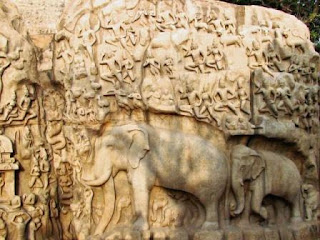
When we visited during the last week of January, the Mahabalipuram dance festival was being staged. The stage was set in front of the Arjuna's Penance Bas relief rock. Arjuna’s Penance made on the worlds largest Bas relief rock measuring 27 meters by 9 meters. The huge whaleback shaped rock contains figures of gods, demigods, men, beasts and birds and in fact can be said to represent creation itself. Measuring 96 feet long by 43 feet high, the bas-relief is also known as The Descent of Ganga. The dance performances at night with the Arjuna's penance bas relief rock as back ground was a great setting.

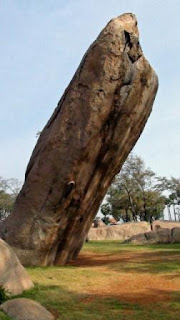
Tiger's Caves is near the coastal village of Salurankuppam which is only 5 kms to the north of Mahabalipuram. This amazing mandapa contains a shrine that is dedicated to the goddess Durga. There are large and impressive figures located in front of the caves. There is a well developed park around the caves. Many huge boulders, some shaped like Obelisk can be found in this park. I was really impressed by these huge boulders and felt like painting them and climbing them. This is a relatively quieter place compared to Mahabalipuram with a quick access to the beach on foot from here.


Friday, December 24, 2010

A Random walk from Cubbon Park to KR Market-12 Dec10

These are some of the images that i captured one fine Sunday Morning on a random walk from Cubbon Park, Bangalore to KR Market in old bangalore area.


Town Hall of Bangalore


The UB City Mall viewed from Cubbon Park


At the gates of Cubbon Park


Sunlight filtering through the buildings of Bangalore onto Cubbon Park


Early Morning Vegetable Market Scene in KR Market


The smiles on the vendors faces are incredible! No matter how harsh the situation they are in, they were all more than happy to have their pictures taken


This was a chance discovery: Mysore Sugar Company Building- an old building with a name which said "Mysugar Building"


This was another chance discovery on JC Road- A statue of Shivaji on top of the Shivaji Cinema building or what used to be the Cinema Building


Bangalore Central Library


Vidhan Soudha Building, Bangalore

These were some of the things i discovered on a random walk down the lanes of Bangalore. I was pleasantly surprised!

Sunday, December 19, 2010

Chitradurga Visit Nov 2010

Chitradurga  is a town in the southern part of the Indian state of Karnataka.  Chitradurga features bold rock hills and picturesque valleys, huge towering boulders in numerous shapes. It is known as the "stone fortress" (Kallina Kote). According to the epic Mahabharatha, a man-eating Rakshasa named Hidimba and his sister Hidimbi lived on the hill. Hidimba was a source of terror to everyone around while Hidimbi was a peace loving rakshasa . When the Pandavas came with their mother Kunti in the course of their exile, Bhima had a duel with Hidimba in which Hidimba was killed. Thereafter Bhima married Hidimbi and they had a son named Ghatotkacha who was gifted with magical powers. Legend has it the boulders were part of the arsenal used during that duel. In fact, the boulders on which major part of the city rests belong to the oldest rock formation in the country.


Legend of Onake Obavva- I had read about this legend of Onake Obave in a newspaper recently and it was interesting to visit the spot in the Chitradurga to see where the story was enacted.

During the reign of Madakari Nayaka, the city of Chitradurga was besieged by the troops of Hyder Ali. A chance sighting of a woman entering the Chitradurga fort through an opening in the rocks led to a clever plan by Hyder Ali to send his soldiers through the hole. The guard on duty near that hole had gone home for lunch. The wife of that guard, Obavva was passing by the hole to collect water, when she noticed soldiers emerging out of this opening. Obavva was not perturbed. She was carrying with her an Onake (a long wooden club meant for pounding paddy grains). She killed Hyder Ali's soldiers one by one as they attempted to enter the fort through the opening and quietly moved the dead. Over a short period of time hundreds of soldiers entered and fell, without raising any suspicion. Obavva's husband, upon his return from his lunch was shocked to see Obavva standing with a blood stained Onake and hundreds of dead bodies of the enemy around her. The opening in the rocks still remains as a historical witness for the story, beside the Tanniru doni a small water source which holds cold water all round the year. Though her sincere and brave attempt saved the fort on that occasion, Madakari Nayaka could not repel Hyder Ali's attack in 1779. In the ensuing battle, the fort of Chitradurga was lost to Hyder Ali. Obavva, like Kittur Rani Chennamma remains a legend, especially to the women of Karnataka.
The fort is a great place to spend a day and rest overnight in a nearby hotel.  It is about 200 kms from Bangalore on NH4.  The road is great and four laned and one can do it in a quick time.  Chitradurga can also be made a stop on the way to Hampi.

Saturday, December 11, 2010

Its December-2010

Another weekend is on us...luckily its a bright sunny day here in Bangalore..the controversy on the treatment given to the Indian Ambassador in the US is on my mind today...i wrote about it on FB and my friends responded...why can't countries at least follow the written diplomatic protocol and why do they have to be reminded everytime?? And how long do we keep reminding the US about it and why shouldnt we reciprocate in kind? Not very diplomatic!! huh!!

Sunday, April 4, 2010

Melkote-Thonnur Lake Trip-April 2010

It was a great experience going with the BWS members namely: Sukanto, Veeresh and Shaji. I started early around 5.40 am and picked up Veeresh, Shaji and Sukanto in that order. Stopped to have coffee and idlis at a restaurant on the Mysore road around 7 am. Reached the first temple around 9.45 am (we stopped frequently on the way to take random pictures). First stop was Cheluvanarayana Swamy Temple, where we spent more than an hour and fifteen mins to take pictures of the amazing scuptures of gods and goddesses in the temple.
It was already getting hot and we then made our way to the next temple - about a couple of kms away by the name of Yoga-Narasimha Swamy Temple. This temple was situated on the top of a hill and we had to walk/climb barefoot for half hour to reach the top after parking the car at the base. The sculptures here were few but the surrounding views of the valley were amazing. Pushkarni pond with the steps leading to the waters were beautiful. On our way down the steps we caught hold of a buttermilk vendor and drank 25 glasses (small) of buttermilk! It was getting really hot and we quickly drove to Thonnur Kere (Lake) which was about 12 kms from the Yoga-Narasimha Swamy Temple. It is a beautiful lake and people were enjoying a swim in the cool waters on a very hot day. We spent some time walking around and clicking away to glory. We started our return journey around 1.30 pm and lost our way and took a different route to return to Bangalore. On the way we stopped at a roadside restaurant to have food and drinks. It was a really hot day but i can safely assume that all four of us thoroughly enjoyed it.
We reached Bangalore by around 6.30 pm and covered a good 330 kms round trip. I really enjoyed the trip and learnt a few tricks from the photographers in the group. Apologies for the late posting as i have been down with stomach problem and was catching up on sleep. I look forward to more such trips in the future.